

Philadelphia, New Jersey under 'critical' wildfire threat as unusual dry thunderstorm pattern looms

Philadelphia, New Jersey under 'critical' wildfire threat as unusual dry thunderstorm pattern looms
A highly unusual weather pattern is bringing critically dangerous wildfire conditions to a swath of the Northeast, including the Philadelphia and New Jersey area. Credit: FOX Weather
PHILADELPHIA - A highly unusual weather pattern is bringing critically dangerous wildfire conditions to a swath of the Northeast, including the Philadelphia and New Jersey area.
Meanwhile, wildfire smoke from multiple blazes already burning across Canada has flooded the skies with renewed haze and poor air quality.
A deep and dry layer of air moved into the Great Lakes Monday night and is spreading into parts of the Northeast on Tuesday, dropping the humidity to as low as 25% and bringing a swath of breezy, gusty winds.
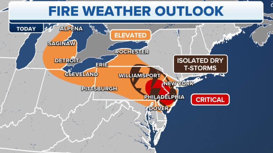
The fire weather outlook for Tuesday, June 6, 2023. (FOX Weather)
Meanwhile, an upper-level trough of low pressure is expected to trigger a round of "dry" thunderstorms across parts of the mid-Atlantic – common in the Desert Southwest but rare in the East.
WHY DRY THUNDERSTORMS POSE WILDFIRE RISKS
With the dry air in place, any rain may evaporate before reaching the ground, meaning lightning strikes may come without any wetting rainfall. With recent dry weather leaving the ground parched, any lighting strike could start a fire that would have the potential for rapid spread amid the breezy and dry conditions.
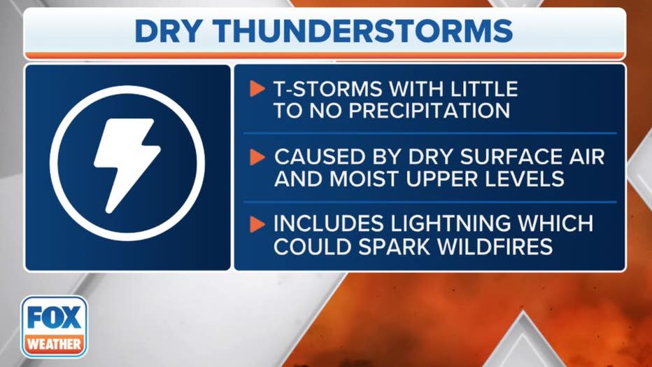
This graphic explains the formation of dry thunderstorms. (FOX Weather)
NOAA's Storm Prediction Center has issued a "critical" wildfire risk – a level 2 on its 3-rung scale for fire weather danger – for nearly 8 million people around the Philadelphia and southern New Jersey area. Fire Weather Warnings are also in effect for the region.
A level 1 "elevated" wildfire risk extends across much of the rest of Pennsylvania and into the eastern Great Lakes, including the cities of Cleveland, Detroit, Buffalo and Pittsburgh.
An elevated risk of wildfires continues for much of the same area into Wednesday.
Canadian wildfire smoke pours into Northeast
Massive plumes of smoke from wildfires burning across several Canadian provinces will drift south into the Northeast on Tuesday, prompting air quality alerts for much of the region.
Meanwhile, smoke from several wildfires already burning across multiple sections of Canada is flooding much of the northeastern U.S., turning skies from blue to a gray-orange haze and bringing unhealthy air quality to major cities, including New York City.
New York City issued a Code Red day for Air Quality as particulate measurements reached over 150 --- squarely into the "unhealthy" category. At those levels, some members of the public may experience health effects, while members of sensitive groups may experience more serious health effects.
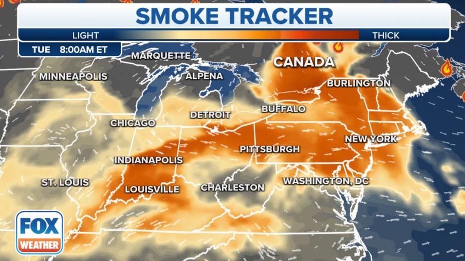
Smoke from Canadian wildfires spreads across the Northeast and mid-Atlantic, even into the Great Lakes. (FOX Weather)
But Air Quality Alerts covered much of New England, including Boston area and all of Connecticut and Rhode Island.
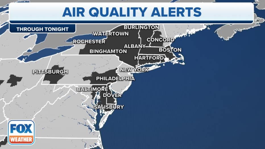
Air quality alerts are in effect on Tuesday, June 6, 2023. (FOX Weather)
Here, air quality officials are warning that children, older adults, and those with heart or lung disease should avoid prolonged exertion and beware of increased respiratory symptoms.
Smoke remains in forecast for Northeast
The smoke import shows no signs of letting up as massive wildfires burn in three different areas of Canada.
A new wildfire in Quebec is the source for much of New York City's smoke Tuesday morning, but additional fires are still burning in Nova Scotia and in Alberta.
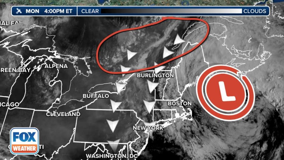
An upper-level low off the New England coast is pushing smoke from wildfires in Quebec into New York. (FOX Weather)
‘UNPRECEDENTED FIRE WEATHER SEASON’ ALREADY CHARRED 9.39 MILLION ACRES ACROSS CANADA
In all, over 400 fires are burning in Canada that have scorched 9.39 million acres -- already 17 times the 20-year average with peak summer wildfire season still yet to come.
"We are already seeing one of the worst wildfire seasons on record, and we must prepare for a long summer," said Steven Guilbeault, Canada's Minister of Environment and Climate Change, at a press conference.