

Nor'easter makes direct hit on Jersey Shore, bringing 70 mph gusts and flooded streets

Tracking the nor'easter: Coastal flooding and Philly rain timeline
A nor'easter continues to push onshore Sunday, bringing persistent showers. While the heaviest rain will break up over the next few hours, expect lingering showers through the evening.
NEW JERSEY - A powerful early-season nor'easter is making a direct hit on the New Jersey coastline this weekend, plunging the state into a state of emergency and bringing coastal life to a standstill.

Nor'easter floods Jersey Shore, prompting emergency rescues with streets underwater
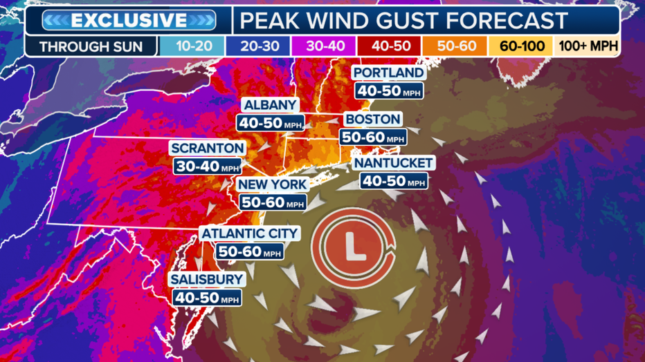
A powerful Nor'easter has slammed the New Jersey coast, bringing heavy rain, 60 mph wind gusts, and severe flooding to coastal communities from Atlantic City to Wildwood.
What we know:
Dangerous wind: Wind gusts between 60 and 70 mph are ripping across the state, churning up ocean waves reaching 15 to 18 feet high. The intense surf has already caused severe beach erosion, and access to Long Beach Island was temporarily severed Saturday morning due to extreme flooding.
Major flooding: The National Weather Service has issued a coastal flood warning in effect through Sunday for the region. Forecasters expect minor to moderate coastal flooding, with spotty major coastal flooding possible along the back bays.
The most intense impacts will coincide with the Sunday morning high tide, followed by additional minor flooding during the Sunday evening high tide.
What's next:
Residents should prepare for widespread roadway flooding in coastal and bayside communities, which could damage susceptible structures and render some roads entirely impassable.
The powerful winds are expected to knock out power to thousands before the system finally begins to weaken late Sunday night. By Monday, wind gusts will drop to the 20 to 30 mph range, though rough surf and residual high-tide flooding will persist along the shore.
The Source: Information from this article was provided by FOX WEATHER and the National Weather Service.