

Weather improves, thousands of evacuated Californians return home after wildfires

Cal Fire proves an update on the SCU Lighting Complex Fires
The update was held at 3:00 p.m. on Friday, August 28, 2020.
SANTA CRUZ, Calif. - California wildfires were slowly being corralled Friday as cooler, humid weather and reinforcements aided firefighters and tens of thousands of people were allowed back home after days of death and destruction.
In the past two days, evacuation orders were lifted for at least 50,000 people in the San Francisco Bay Area and wine country, officials with the state fire agency, Cal Fire, said Thursday evening. At their peak, some 170,000 people were under evacuation orders.
In heavily damaged areas, crews were working to restore electricity and water so more people could return to their homes, Santa Cruz County Chief Deputy Chris Clark said. Evacuation orders for more than 20,000 people were lifted over the past 24 hours in San Mateo and Santa Cruz counties. And more good news: Clark said Friday that no one returning home had been burglarized while they were gone.
Clark also added that three missing people had been accounted for, though he was looking into one missing person report.
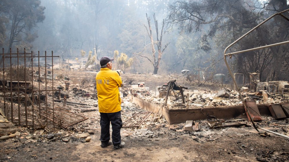
David Serna, a veteran firefighter, found himself on the other side of the fireline. He returned home to find his home destroyed in the CZU Lightning Complex Fire.
By Friday evening, Cal Fire said that the CZU August Lightning Complex Fire in Santa Cruz and San Mateo counties had burned about 83,133 acres and was 27% contained. A total of 831 structures were destroyed, and 554 of those were homes. All but 11 structures were located in Santa Cruz County. A total of 13,000 structures remained threatened.
"We expect really good work today," said Cal Fire Battalion Chief Mark Brunton.
Meanwhile, fire crews found an odd discovery while mopping up spot fires near the Boulder Creek Golf Club on Thursday. They found an explosive device that appeared to be a pipe bomb inside a toolbox. The sheriff's bomb squad safely detonated the device.
Around the state, hundreds of wildfires — coming months earlier in the season than expected — have already killed at least seven people, burned more than 2,000 square miles and pushed firefighter resources to the breaking point. Two are among the largest wildfires in recent state history.
But a heatwave eased this week, and in the past few days cooler, more humid weather patterns have slowed the spread of three massive complexes of wildfires in the north.
In addition, personnel, aircraft and bulldozers have been arriving from other states and California National Guard troops have joined the fight, authorities said.
In the eastern San Francisco Bay Area, the SCU Lightning Complex Fire that has burned in seven counties had burned about 374,471 acres by Friday and was 40% contained.
Cal Fire said three first responders and two civilians were injured in the fire, but the agency did not elaborate on the extent of those injuries.
Further north, the LNU Lightning Complex Fire had burned more than 372,344 acres and was 35% contained by Friday.
That fire complex, the site of five deaths, still threatened 30,500 homes and other buildings after destroying 1,080.
Cal Fire noted that burned out unstable wooden bridges, burned asphalt, trees and power lines have been falling down and these issues will have to be addressed before letting people move back in.
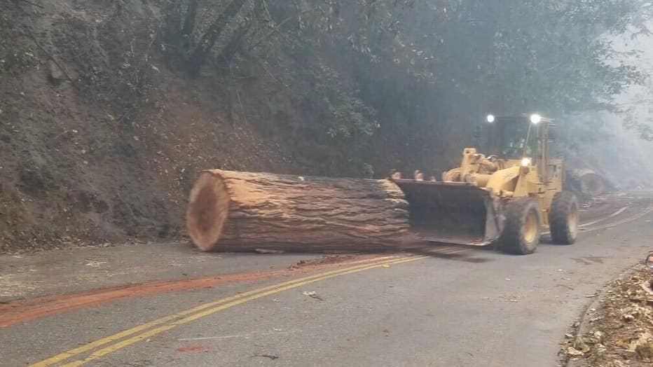
Still, there were areas that were deemed safe for "repopulation." Firefighters and utility workers were clearing areas for returning residents.
In the heart of wine country, evacuation orders in Napa and Sonoma counties were lifted Wednesday for about 35,000 people who had been told to leave after lightning ignited dozens of blazes more than a week ago starting the LNU fires.
Cal Fire said there still was “extreme fire behavior” and portions of the three-pronged fire continued to advance in several directions.
Even after the wildfires are contained, thousands of firefighters will have to remain on the firelines to douse smoldering timber and hot spots to prevent flareups.
The Associated Press contributed to this report.
*********************************************************************************************************
Evacuations Orders (SCU):
SANTA CLARA COUNTY
Zone 2A
East of the fire perimeter to Mines Rd. and San Antonio Rd.
West of Mines Rd. and San Antonio Rd. to the fire perimeter
South of the Alameda/ Santa Clara County Line to Hwy 130
North of Hwy 130 to the Alameda/ Santa Clara County Line
Zone 3A
East of San Felipe Rd. to the Santa Clara/Stanislaus County Line
South of Mt. Hamilton/Hwy 130
West of Santa Clara/Stanislaus County Line to San Felipe Rd.
Zone 5A
South of a straight line from the East end of Metcalf Road to the Stanislaus County Line.
East of Shingle Valley Road, east of Anderson Reservoir, East of Coyote Creek, East of Coyote Lake to the Stanislaus County Line.
North and east of Gilroy Hot Springs Road.
East of Canada Road from Gilroy Hot Springs Road to Jamieson Road.
North of Jamieson Road.
All areas east of a straight line from the East end of Jamieson Road to Hwy 152 offramp to Casa de Fruta to the Stanislaus/Merced County Line.
North of Hwy 152 offramp to Casa de Fruta to the Merced County Line
Zone 9
South of the Alameda/Santa Clara County Line in between Mines Rd. and the Stanislaus/San Joaquin County line to Del Puerto Canyon Rd.
East of Mines Rd to Santa Clara/Stanislaus County Line
North of Del Puerto Canyon Rd. to Alameda/Santa Clara County Line in between Mines Rd. and the Stanislaus/San Joaquin County
West of Santa Clara/Stanislaus County Line to Mines Rd. in between the Alameda/Santa Clara County Line and Del Puerto Canyon Rd.
STANISLAUS COUNTY
Zone 7A:
Remainder of Stanislaus county within the current fire perimeter
Alameda County:
Zone 12:
All of Mines Road, south of Mile Marker 10 to the county line
Zone 15F:
South of fire perimeter to the Alameda/Santa Clara County Line
San Joaquin County:
Zone 10A:
South of the fire perimeter to the Alameda & Stanislaus County Line
Evacuation Warnings:
ALAMEDA COUNTY
Zone 15A:
South of Tesla Rd., South of the Livermore City limits (excluding the cities of Livermore and Pleasanton), South of Hwy 84 in between Vineyard Ave. and I-680, South of I-680 to the fire perimeter and the Alameda/Santa Clara County Line.
West of the Alameda/San Joaquin County Line to the Livermore city limits, to Calaveras Rd
North of fire perimeter and the Alameda/Santa Clara County Line to Hwy 84, to the Livermore city limits
Zone 15B:
South of Welch Creek Rd. to the fire perimeter and the Alameda/Santa Clara County Line
East of Calaveras Rd. at Welch Creek Rd. to the fire perimeter
Zone 19:
Inside of the Ohlone Fire Perimeter
SANTA CLARA COUNTY
Zone 2B:
East of Sierra Rd. and Felter Rd., East of Milpitas and San Jose City Limits to the fire perimeter
North of Mt. Hamilton Rd. to the Alameda/Santa Clara County Line
*Marsh Rd. remains closed at the fire perimeter located at Arroyo Hondo Bridge
Zone 3C:
Quimby Rd.north to Hwy 130
East of San Jose city limits to Mt. Hamilton Rd
South of Mt. Hamilton Rd. to Quimby Rd.
Hamilton Rd. west to the San Jose City Limits
Zone 6:
East of Lovers Lane and the Santa County Line
South of Hwy 152 to the San Benito County Line West to the Merced County Line
North of the San Benito County Line to Hwy 152
Temporary Evacuation Points:
Creekside Middle School:535 Peregrine Dr, Patterson, CA 95363
Milpitas Library: 160 N Main St Milpitas, CA 95035
Road Closures:
Mines Road at DelValle Road. DelValle residents only. (Dublin CHP)
The intersection of Mines Road, Del Puerto Canyon Road, and San Antonio Valley Road. No Traffic north or south (west) from intersection. (Dublin CHP)
Quimby Road at Mount Hamilton Road. Hard Closure. (San Jose CHP)
Metcalf Road at San Felipe Road. No traffic south of the intersection. (Hollister-Gilroy CHP)
E. Dunne Ave at Holiday. No traffic east of the intersection. (Hollister-Gilroy CHP)
Roop at Coyote Reservoir. No traffic north or east of intersection. (Hollister-Gilroy CHP)
Canada at 152. No traffic north of the intersection. (Hollister-Gilroy CHP)
Bell Station, north of 152. No traffic north of 152. (Hollister-Gilroy CHP)
Animal Evacuation Points:
County of Santa Clara Animal Services: (408) 686-3900
For the unincorporated areas of Santa Clara County, Morgan Hill, and Gilroy -- Hold Your Horses Livestock: (925)584-1976
Large Animals in Canyon Zone
Alameda County Animal Services: (925)803-7041
Large and Small animal shelter and assistance
LNU EVACUATION INFORMATION:
SOME EVACUATION ORDERS LIFTED – Sonoma County
WHAT:
Evacuation Orders(s) Lifted: The formal announcement of lifting evacuations in an area currently under evacuation.
WHEN:
Effective Immediately
WHEN:
WHERE:
The following areas are downgraded from Evacuation Order to Evacuation Warning:
A portion of zones 1D5 downgraded from Evacuation Order to Evacuation Warning
Westside Road south of Sweetwater Springs Road
North of the Russian River
West of the Hacienda Bride to Korbel
NOTE: McPeak Road north of Wasson Road remain order
NOTE: Mount Jackson resort Road to remain under order
A portion of zones 1B3 downgraded from Evacuation Order to Evacuation Warning
North and East of Lion Head Ranch Road at King Ridge Road
South West of 14900 Stewart Point Skaggs Springs Road
NOTE: Remainder of the zone still under Evacuation Order
NOTE: Lion Head Ranch Road under evacuation order
The following areas have had all evacuation orders lifted:
Map Grid 2A2 Evacuation Order Lifted
North of the Dry Creek and the norther fork of Lake Sonoma County
West of Dutcher Creek, City of Coverdale city limits and Hwy 128
South of the Mendocino County line
TCPs to change to:
Sweetwater @ Westside (Moved from Wholer @ Eastside Road)
River Road @ McPeak just west of Korbel (Moved from River Road @ River Drive)
To learn more about wildfire preparedness visit:
https://www.readyforwildfire.org/
Mountain Jackson Resort Road at Westside Road (Moved from River Road @ Odd Fellows Road)
McPeak Road @ Wasson Road (New)
Sewell @ King Ridge (Already in Place)
14900 Stewarts Point Skaggs Springs Road (Moved from 22303 Skaggs Springs Road)
King Ridge Road at Cazadero Highway (Already in place)
Move TCP from Dutcher Creek @ Dry Creek to the Fish Hatchery
NOTES: SAFETY MESSAGE – The public is reminded to stay vigilant on current fire conditions. Please continue to adhere to road closures and any evacuation warnings or orders. A reminder to drive slowly and yield to emergency personnel in the area. There will be smoke in the respective areas as firefighters continue firefighting operations. If at any time you feel unsafe, please call 911.
Access will be limited to residents only; no other public access will be granted at this time.
Coming home after a wildfire can be difficult. As evacuations are lifted please review the safety steps when returning to your home after a wildfire. For information on returning home visit us at:https://www.readyforwildfire.org/post-wildfire/returning-home//
LNU LIGHTNING COMPLEX ONLINE STRUCTURE DAMAGE MAP NOW AVAILABLE
LNU LIGHTNING COMPLEX INCIDENT UPDATE 8/28/20 7PM
Damage inspection teams have been assigned to the incident and conducting a thorough inspection of the affected area. Repopulations continue to occur in many communities throughout the fire zone as areas are determined safe for return. Crews will take advantage of favorable conditions this evening to construct additional control lines.
Napa County and Lake County:
Hennessey Fire (Merged Fires - Gamble, Green, Aetna, Markley, Spanish, Morgan, Round): Hennessey Ridge Road in Napa County, California. The fire is currently 314,631 acres and 37% contained.
Sonoma County:
Walbridge Fire (merged with Stewarts): West of Healdsburg. The fire is currently 55,353 acres and 28% contained
Meyers Fire: North of Jenner. The fire is currently 2,360 acres and 99% contained.
EAST ZONE (NAPA COUNTY) EVACUATION AND ROAD CLOSURE INFORMATION
Evacuation Order:
Napa County:
OES Info: https://www.countyofnapa.org/353/Emergency-Services
Evac Info: https://www.countyofnapa.org/CivicAlerts.aspx?AID=182
Napa County Information Line: (707) 253-4540
https://www.countyofnapa.org/2966/19746/LNU-Wildfires
Highway 128 between Monticello Dam and Moskowite Corners (SR128/121 intersection)
Wragg Canyon
Markley Cove
Pleasure Cove
Highway 121 (Monticello Rd) Between Moskowite Corners(SR128/121 intersection) and Longhorn Ridge Road
Highway 128 (Capell Valley Road/Sage Canyon Rd) from Chiles Pope Valley Road to Hwy 121 (Monticello Road)
Steel Canyon Road
Community of Berryessa Highlands
Chiles and Lower Chiles Pope Valley Roads
Berryessa-Knoxville Road from Hwy 128 (at Turtle Rock) to Lake County Line
Community at Spanish Flat Loop Road
Community of Berryessa Pines
Both sides, including resorts and recreational areas of Lake Berryessa, Knoxville
Atlas Peak Road from 3683 Atlas Peak Road (Circle R Ranch) to the dead end
Ink Grade from White Cottage Road to Pope Valley Road
Howell Mountain Road from White Cottage Road east to Pope Valley Road
All of Pope Valley Road and connecting roads
Pope Valley Cross
Hardin
Aetna Springs Road
James Creek Road
All of Butts Canyon Road and connecting Roads in Napa County of Napa
Snell Valley Road
Stagecoach Road
Community of Berryessa Estates
Properties on the east side of Highway 29 between Silverado Trail and Lake County line
Old Lawley Toll Road
Palisades Road
Evacuation Warning:
Properties on the east side of Silverado Trail from Rosedale Road to Deer Park Road.
Howell Mountain Road (AKA Old Howell Mountain Road) up to the intersection of White Cottage Road and Deer Park Road. Also included is Conn Valley Road and all roads in between.
Howell Mountain Road from Deer Park Road to White Cottage Road, including the community of Angwin
White Cottage Road
Soda Canyon from Loma Vista to 3700 Soda Canyon Road (Dead End)
Atlas Peak from 2462 Atlas Peak Road (Bubbling Wells Pet Cemetery) to 3683 Atlas Peak Road.
Deer Park Road from Silverado Trail to the intersection of White Cottage Road and Howell Mountain Road. This will include the community of Deer Park, Glass Mountain, Crystal Springs, and St. Helena Hospital
EAST ZONE Napa County Evacuation Center:
Crosswalk Community Church
2590 First Street
Napa, CA 94558
EAST ZONE Napa County Road Closures:
SR-121 at Circle Oaks – closed East bound
SR-128 at Napa/Solano County Line - No traffic West bound
Butts Canyon Rd at Guenoc
SR-128 at Silverado Trail.
Atlas Peak Rd at Circle R Ranch
Howell Mountain Road
Deer Park is closed at Silverado Trail
Glass Mountain Road and Silverado Trail
Crystal Springs at Silverado Trail
EAST ZONE Napa County Animal Evacuation Center:
Napa County Animal Shelter: 942 Hartle Court, Napa, CA 94559
Valley Brook Equestrian Center: 1132 El Centro Ave. Napa 55 horses
Napa Valley Horseman's Association: 1200 Foster Road Napa 61 horses
Ag 4 Youth 1200 Foster Rd, Napa 62 Ruminants
EAST ZONE (LAKE COUNTY) EVACUATION AND ROAD CLOSURE INFORMATION
Lake County:
https://www.facebook.com/lakesheriff/
Evacuation Map: HERE
OES Contact:
(707) 262-4090
Sign Up for Lake County Alerts:
https://member.everbridge.net/index/892807736729003#/signup
If you are in need of shelter please proceed to a Temporary Evacuation Point (TEP) listed below.
Evacuation Orders:
Hidden Valley Lake / Jerusalem Valley Areas
South of Hofacker Ln. to Morgan Valley Rd.
East of Hwy 29
West of Lake / Napa County line
East of Middletown Area
East of Hwy 29
North of Lake / Napa County line up to the intersection of Hey. 29 and St. Helena Creek (Across from Twin Pine Casino)
St. Helena Creek Rd
South of Butts Canyon Rd.
Lower Lake Area (South)
West of Lake / Napa County line
North of Hofacker Ln. extending east to Morgan Valley Rd. Lower Lake Area (North)
North of Morgan Valley Rd.
East of Sky High Ridge Rd. extending north to Hwy. 20
South of Hwy. 20
West of Lake / Napa / Colusa County lines
Evacuation Warnings:
Middletown Area
West of Hwy. 29
North and East of Lake / Napa
South of Anderson Springs Rd. / Neft Rd. / Boggs Mt. Rec. Area extending northeast to Hwy. 29 / Hofacker Ln.
Lower Lake Area
East of Big Canyon Rd. / Perini Rd. / Seigler Canyon Rd.
South and west of Hwy. 29
North of the previous evacuation order / warning line of Anderson Springs Rd. / Neft Rd. / Boggs Mt. Rec. Area extending northeast to Hwy. 29 / Hofacker Ln.
East Lake County Area
South and West of Lake / Colusa County line
The Evacuation Order has been reduced to an Evacuation Warning for the areas east of Hwy. 29, north of Butts Canyon Road, south of Morgan Valley Road and west of the intersection of Morgan Valley Road and Rocky Creek Road, extending south to the intersection of Butts Canyon Road and Guenoc Road. This includes all residences in the area of Lower Lake, Spruce Grove Road, Hofacker Lane, and Hidden Valley Lake. This does not include Jerusalem Valley or any part within the burn area of the fire which remains as an Evacuation Order.
EAST ZONE Lake County Evacuation Center(s) and/or Temporary Evacuation Point(s):
Temporary Evacuation Point (TEP)
Kelseyville High School parking lot 5480 Main Street Kelseyville, CA
Lower Lake
Morgan Valley Road EB @ Sky High Ridge Rd
Spruce Grove Road (North) EB @ SR 29
Clayton Creek Road EB @ SR 29
Hofacker Lane EB @ SR 29
Lake Ridge Road NB @ Morgan Valley Rd
A Street EB @ SR 29
Hidden Valley Lake
Spruce Grove Road (South) EB @ SR 29
Hartman Road EB @ SR 29
Grange Road EB @ SR 29
Middletown
Butts Canyon Road EB @ SR 29
EAST ZONE (YOLO COUNTY) EVACUATION AND ROAD CLOSURE INFORMATION
Evacuation Order
Zone 1
Zone 2
Evacuation Warning
Zone 3
Colusa County:
Evacuation Order
Zone C1
All areas and residents West SR-16, South of SR-20, East of the Colusa/Lake County Line.
Zone C2
All areas and residents North of the Colusa/Yolo County Line, East of SR-16, West of Sand Creek/Green Road, and South of the dead end of Spring Valley Road.
Zone C3
All areas and residents South of Walnut Drive, West of Spring Valley Road/Walters Creek/Corinthia-Vineyard Road, East of SR-20, and North of the intersection of SR-20/SR-16, extending East to the dead end of Spring Valley Road.
Zone C4
All areas and residents South of Brim Road/Old Leesville Grade/Leesville Road, East of the Colusa/Lake County Line, West and North of SR-20.
EAST ZONE (SOLANO COUNTY) EVACUATION AND ROAD CLOSURE INFORMATION
Evacuation Order has been reduced to an Evacuation Warning. Only residents are permitted to re-enter the area with appropriate Identification.
Phase 1
This phase went into effect on August 27, 2020. This phase included residents who live in the areas West of Interstate 80 from Lyon Road to Vaca Valley Road, including Vaca Valley Road. Gates Canyon Road will remain closed.
Phase 2
Today, August 28, 2020 phase 2 has gone into effect and includes the area north of Vaca Valley Road up to Cantelow Road and from Pleasants Valley Road to Gibson Canyon Road. Cantelow Road from Pleasants Valley Road to English Hills Road will remain closed. Mix Canyon Road will remain closed.
The following road closures will remain even after phased reopening. Road closure removal will be determined at a future date. Access will remain restricted due to road damage, utility needs and falling trees.
Gates Canyon Road
Mix Canyon Road
Blue Ridge Road
Cantelow Road from Pleasant’s Valley Road to English Hills Road
Pleasant’s Valley Road from Shale Peak Lane to Quail Canyon Road
WEST ZONE (SONOMA COUNTY) EVACUATION & ROAD CLOSURE INFORMATION
Sonoma County:
socoemergency.org
Residents and visitors can dial 2-1-1
You can also view an interactive evacuation map here
Livestock 707-234-7193.
Evacuation Order:
Evacuation Zone - 1B3
East of McCray Ridge Road and Pool Ridge
North of Old Cazadero Road
West of King Ridge Road
South Skaggs Springs Road
Evacuation Zone - 1D4 and 1D5
The community of Rio Nido remains under an Evacuation Order
Residents returning to Guerneville must utilize Hwy 116/Pocket Canyon, Bohemian Highway or Highway 1
Area of Old Cazadero Road north of Old Cazadero Road @ Chimney Rock Road remaining under Evacuation Order
Pool Ridge Road remains under Evacuation Order
Evacuation Zone - 2A3
North of Stewarts Point Skaggs Springs Road to the eastern edge of Lake Sonoma
Everything west of the eastern edge of Lake Sonoma to the western boundary that runs north along the ridge line from the intersection of Stewarts Point Skaggs Springs Rd @ Old Stewarts Point Skaggs Springs Road to the interception of Rockpile Road @ Cooley Ranch Road north to the Mendocino County Line.
Evacuation Zone - 2E1
South of Stewarts Point Skaggs Springs Road
North of Palmer Creek Road and Stewart Point Skaggs Springs Road
West of McCray Road
East of Wallace Creek Road
Evacuation Zone - 2E2:
South of Stewarts Point Skaggs Springs Road
North of Chemise Road
West of the center of Dry Creek (the actual creek)
East of Wallace Creek Road
Evacuation Zone - 2E3
South of Chemise Road
North of Westside Road
West of the Center of Dry Creek (the actual creek)
East of Wallace Creek Road
Evacuation Zone - 2E4:
South of Palmer Creek Road
North of McCray Ridge Road and Sweetwater Springs Road
East of the Dry Creek (the actual creek)
Evacuation Warning:
Portions of Evacuation Zone - 1D4 and 1D5(Town of Guerneville) downgrading from Evacuation Order to Evacuation Warning
North of Russian River
South Rio Nido Road @ Armstrong Woods Road
West of Foothill Boulevard @ River Road
East of Old Cazadero Road
Evacuation Zone - 2A2
North of the Dry Creek and the norther fork of Lak Sonoma County
West of Dutcher Creek, City of Coverdale city limits and Hwy 128
South of the Mendocino County line
Evacuation Centers: EAST ZONE:
Napa County:
Crosswalk Community Church 2590 First Street Napa, CA 94558
Lake County:
Kelseyville High School parking lot 5480 Main Street Kelseyville, CA 95451 (Temporary Evacuation Point)
Yolo / Colusa / Solano County:
None
Evacuation Centers: WEST ZONE:
Sonoma County:
Temporary Evacuation Points:
Santa Rosa Fairgrounds
1350 Bennett Valley Road Santa Rosa, CA 95404
Petaluma Veterans Building
1094 Petaluma Blvd South Petaluma, CA 94952
Road Closures: EAST ZONE:
Napa County:
SR-128 at Silverado Trail
Chiles Pope Valley Road northbound at SR-128
SR-121 at Circle Oaks
Atlas Peak Road at Circle R Ranch
Deer Park at Silverado Trail
SR-128 westbound at Pleasants Valley Road
Ink Grade Road northbound at White Cottage Road N
Howell Mountain Road northbound at White Cottage Road N
Lake County:
Lower Lake:
Morgan Valley Road eastbound at Sky High Ridge Road
Middletown:
Morgan Valley Road eastbound at Sky High Ridge Road
Yolo County:
SR-16 westbound at County Road 41
County Road 41 northbound at County Road 41A
Colusa County:
SR-16 south/eastbound at SR-20 (staffed by CHP and Caltrans)
Sand Creek Road westbound @ Cortina School Road (unstaffed, locked gate)
Solano County:
Pleasants Valley Road southbound @ SR-128
Pleasants Valley Road northbound at Vaca Valley Road
Gibson Canyon Road southbound at Cantelow Rd
Cantelow Road westbound at Gibson Canyon Rd
Gibson Canyon Road N northbound at Solar Hills Drive
Putah Creek Rd westbound at 3851 Putah Creek Road
Peaceful Glen Rd westbound at Olivas Lane
Road Closures: WEST ZONE:
Sonoma County:
Sonoma County road closures:
River Rd westbound @ River Drive
River Rd eastbound and westbound @ Odd Fellows Park Rd River Rd eastbound @ Hwy 116
Hwy 116 eastbound at Old Cazadero Road (Old Cazadero Road is open)
King Ridge Road northbound and southbound at Sewell Road
King Ridge Road northbound and southbound at Cazadero Hwy
Dry Creek Road westbound at Dutcher Creek Road (no traffic on Dry Creek to Skaggs Springs Road)
Yoakim Bridge Road westbound at Dry Creek Road
Lambert Bridge Road westbound at Dry Creek (no traffic west, across the bridge)
Westside Road westbound at Hendricks Street (no traffic west of the bridge)
22303 Skaggs Springs Road eastbound at Anvil Ranch
Wohler Road/Westside Road northbound at Eastside Road (Eastside Road is open)
Foothill Boulevard at River Road
Old Cazadero Road at Chimney Rock
Armstrong Woods Road at Rio Nido Road
15000 block of Gabes Rock Road
Animal Evac. Center(s): EAST ZONE:
Napa County:
Napa County Animal Shelter 942 Hartle Court Napa, CA 94559
Valley Brook Equestrian Center 1132 El Centro Ave. Napa 55 horses
Napa Valley Horseman's Association, 1200 Foster Road Napa 61 horses
Ag 4 Youth 1200 Foster Rd, Napa 62 Ruminants
Yolo County:
SR-16 westbound @ County Rd 41
County Rd 41 northbound @ County Rd 41A
Colusa County:
SR-16 eastbound @ SR-20
Sand Creek Rd westbound @ Cortina School Rd
Lake / Solano County:
Animal Evac. Center(s): WEST ZONE::
Sonoma County:
None
CZU EVACUATION INFORMATION
EVACUATION WARNINGS FOR SAN MATEO COUNTY:
No Evacuation Warnings currently in place
EVACUATION ORDERS FOR SAN MATEO COUNTY:
Communities of Loma Mar and Dearborn Park Area (Zone SMC E018) (8/18/2020 5:00 pm)
Pescadero Creek County Park Area (Zone SMC E024)) (8/18/2020 4:30 pm)
Butano Community Area (Zone SMC E098) (8/18/2020 5:00 pm)
Butano State Park Area including Barranca Knolls Community (Zone SMC E019) (8/18/2020 4:30 pm)
Butano Creek Drainage (Zone SMC E055) (8/18/2020 4:30 pm) (8/18/2020 4:30 pm)
South Skyline Blvd. Area near Highway 9 (SMC E049) (8/18/2020 11:00 pm)
Russian Ridge Open Space Reserve Area (Zone SMC E027) (8/18/2020 11:00 pm)
(Zone SMC E048) (8/18/2020 11:00 pm)
Red Barn Area (Zone SMC E010) (8/20/2020 6:00 pm)
EVACUATION WARNINGS FOR SANTA CRUZ COUNTY:
No Evacuation Warnings currently in place
EVACUATION ORDERS FOR SANTA CRUZ COUNTY:
Waterman Gap Loop, Upper HWY 236, Boulder Creek Golf Course, Heartwood Hill, Lodge Road, Community of Little Basin, Lower China Grade, Upper China Grade, Community of Kings Hwy, Lower Jamison Creek, Gallion Heights, Fallen Leaf Neighborhood, Foxglove Lane (Zones CRZ10, CRZ13, BOU36, BOU20, BOU30, BOU31, BOU36, BOU37, BOU21) (8/18/2020 10 pm)
Saratoga Toll Road, San Lorenzo Park, Riverside Grove-Community of Teilh Drive, Wildwood Road (BOU38, BOU39, BOU40, BOU41, BOU42, BOU43) (8/18/2020 10 pm)
Everyone on Empire Grade Road, from Felton Empire north, all of Pine Flat Road, all of Ice Cream Grade, Bonny Doon Road, in between Pine Flat Road, Martin Road, and all associated side streets are under an evacuation order. Areas west of State Route 35 from San Mateo County Line to State Route 17. (CRZ1, CRZ2, CRZ3, CRZ4, CRZ5, CRZ10, CRZ11, CRZ12, CRZ13, CRZ14, CRZ15) (8/19/2020 1:00 am)
Bonny Doon south of Ice Cream Grade, to include Pine Flat Road South. (CRZ7, CRZ8) (8/19/2020 1:00 am)
Areas of Alba Road, Hubbard Gulch and Fanning Grade. (BEN 1) (8/19/2020 6:00 pm)
All areas of Ben Lomond (Zones BEN 2 – BEN 5) (8/19/2020 7:00 pm)
All areas adjacent to the Bonny Doon and San Lorenzo Valley should be prepared to evacuate if necessary. (CRZ7, CRZ8) (8/20/2020 1:00 am)
Areas West of Highway 9 to Empire Grade
South from Bear Creek Road to Felton, this includes Ben Lomond
The areas of Zayante Canyon (Zones: ZAY 1 – ZAY 17) (8/20/2020 1:00 pm)
Davenport south (Zones: CRZ 6, CRZ 9, CRZ 17) (8/19/2020 7:00 pm)
All areas of Felton (Zones: FEL 1 – FEL 6) (8/20/2020 8:00 am)
Butano State Park area including Barrranca Knolls Community (Zone: SMC E019) (8/18/2020 4:30 pm)
EVACUATION CENTERS
San Mateo County
Half Moon Bay High School, 1 Lewis Foster Drive, Half Moon Bay
Santa Cruz County
Santa Cruz County Fairground, 2601 E. Lake Avenue in Watsonville
Santa Cruz Civic Auditorium, 307 Church Street, Santa Cruz (AT CAPACITY)
Seventh Day Adventist Camp Grounds, 1931 Soquel San Jose Rd (AT CAPACITY)
Cabrillo College, 6500 Soquel Drive, Aptos CA
Simpkins Family Swim Center, 919 17th Ave (ADA only)
Twin Lakes Church, 2701 Cabrillo College Drive
ROAD CLOSURES
Road closures are fluid and being coordinated with evolving evacuation warnings and orders.
San Mateo County
State Route 1 at Gazos Creek
Cloverdale Road between Pescadero Creek Road and Gazos Creek.
Pescadero Creek Road at Butano cut off
Pescadero Creek Road at Burns Valley Road
Santa Cruz County
State Route 1 at Shaffer Road to Ano Nuevo
State Route 9 at State Route 35 to Paradise Park Exit Road
Empire Grade at Twin Gates
Bear Creek Road at Amber Ridge Loop to Boulder Creek
Quail Hollow Road at Marion Way
Hihn road at Stanford Drive
Graham Hill Road at Mount Hermon Lane to State Route 9
Animal Evacuation Center:
Santa Cruz County Fairgrounds, 2601 E. Lake Avenue in Watsonville
Large farm animals are being accepted at Cowpalace. For information and assistance contact (650) 450-0520.
Watsonville Animal Shelter, 580 Airport Blvd