

Hurricane Erin: State of Emergency declared in New Jersey amid dangerous impacts

Beaches remain packed after Hurricane Erin causes flooding
Beachgoers remained packed on the beaches in Ocean City after a treacherous night of flooding caused by Hurricane Erin spinning miles off shore.
NEW JERSEY - Shore towns in New Jersey and Delaware are bracing for the worst of Hurricane Erin as the sprawling storm continues traveling up the East Coast on Thursday.
What we know:
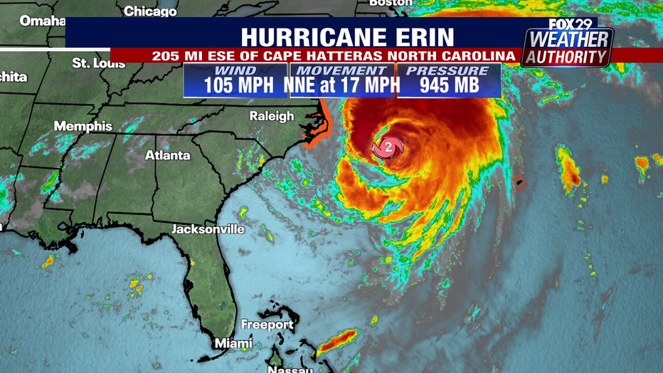
Hurricane Erin was still a Category 2 storm as it moved to the north and northeast with maximum sustained winds of 105 mph on Thursday morning.
While Erin is not expected to make landfall in the U.S., it will still pose a variety of threats to beachgoers in New Jersey and Delaware.
State of Emergency
Local perspective:
New Jersey Gov. Phil Murphy declared a State of Emergency across all 21 counties starting at 2 p.m. Thursday in preparation for Hurricane Erin.
"Over the past couple of days, we have seen the effects of Hurricane Erin along the Jersey Shore in the form of dangerous rip tides. Today and tomorrow will be no exception," Gov.Murphy said. "As the storm moves past New Jersey over the next 24 hours, we are expecting high surf and rip currents, coastal and flash flooding, and a high erosion risk in parts of the state. We ask all New Jerseyans to monitor local weather forecasts and warnings and stay informed on evacuation protocols, especially if you’re down the Shore."
Flood and rip current warnings
Dig deeper:
The highest impacts of Hurricane Erin are expected to hit the Jersey Shore and Delaware beaches during the afternoon and evening hours on Thursday.
However, warnings and advisories are already in place for several counties.
The National Weather Service issued a coastal flood warning until 2 a.m. on Saturday, a wind advisory from 10 a.m. Thursday to midnight Friday, and rip current warning until 8 p.m. Friday.

What to expect
What's next:
Officials are urging shore residents and visitors to stay out of the water as the storm brings life-threatening impacts:
- Wave heights of 7–12 feet by high tide on Thursday evening
- Wind gusts of 30-40 mph, reaching 50 mph in some areas
- Dangerous rip currents
- Beach erosion
- Coastal flooding

Hurricane Eric triggers coastal flooding and ripe tide warnings to NJ and Delaware
The National Weather Service has issued coastal flood warnings for the Jersey Shore, while warning of dangerous rip currents along the entire East Coast.
On land, the Philadelphia area will see a mostly cloudy Thursday with temperatures in the upper 60s and lower 60s.
Pockets of showers are expected at the shore in New Jersey and Delaware with moderate to major flooding.

'Don't go into the water'
What they're saying:
New Jersey Gov. Phil Murphy held a press briefing Tuesday morning to address the rip current risk posed by Hurricane Erin.
He noted that while the rip currents would be strong and surf would be high, overall the weather would be nice over the next several days as the storm moves off the coast.

Hurricane Erin: Cape May surfers hit the waves despite warnings
With the impact Hurricane Erin has on the Jersey Shore to worsen Thursday, many surfers seized the waves as an opportunity.
"We are worried therefore, in a big way, about human nature and complacency," Murphy said. "We've already had a very tough riptide summer, particularly over the past several weeks."
Murphy referenced the two drowning incidents over the past few weeks in Seaside Heights and Belmar.
Biggest US Threats from Hurricane Erin
Big picture view:
Hurricane Erin isn't forecast to make landfall along the East Coast, but dangerous impacts are expected to impact areas like North Carolina's Outer Banks.
Tens of thousands had been evacuated off the most vulnerable of North Carolina's Outer Banks as a storm surge of up to 4 feet was likely.
While the center of Erin and its peak winds were some 200 miles east-southeast of Cape Hatteras, North Carolina, tropical-storm-force winds extended outward up to 320 miles, reaching parts of the North Carolina and Virginia coastlines, where Tropical Storm Warnings lingered into Thursday.
The greatest impacts from Erin were focused on the central Outer Banks, where waves of up to 20 feet combined with a storm surge of 2–4 feet continued to overwhelm some of the barrier islands.
The Source: Information from this article was sourced from FOX Weather, the National Weather Service and the FOX 29 Weather Team.