

Nor'easter dumps over 2 feet of snow in some parts of the area

PHILADELPHIA - A powerful nor'easter that impacted the Delaware Valley for several days dumped over two feet of snow in some parts of the area.
Lingering snow showers and flurries are expected as the storm moves out.
The I-95 corridor and north and west suburbs saw the highest totals for the duration of the storm. Portions of Delaware and southern New Jersey dealt with less snow and more rain prompting some coastal flooding.
The National Weather Service issued winter storm warnings for most of the area that expired Tuesday afternoon.
TOTALS
As of Tuesday afternoon, several parts of Northampton, Lehigh, and Berks counties reported over 20 inches of snowfall. Nazareth, a borough in Northampton County, is coming in at 35.5 inches.
Bucks County received anywhere between 9 and 31.2 inches of snowfall, while Montgomery, Delaware, and Chester counties reported 6 to 16 inches once the storm departed.
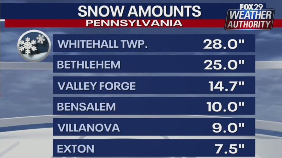
So far, Philadelphia is reporting 7.9 inches of snow.
Southern New Jersey ranged anywhere from 4 to 13 inches and Delaware saw lower totals of 4.5 to 6.5 inches.
TEMPERATURES
Temperatures will drop into the 20s Tuesday night with biting wind chills leading to the possibility of black ice and slippery spots.
Highs will be above freezing for Wednesday that will help the snow to melt, especially with the sunshine.
There's potential for another snow chance on Sunday. The European model shows the storm moving through during the day Sunday; however, the GFS model shows it as a miss.
DOWNLOAD: FOX 29 WEATHER AUTHORITY APP
___
TUESDAY: Storm exits. High: 36, Low: 33
WEDNESDAY: Partly sunny. High: 35, Low: 30
THURSDAY: Mostly sunny. High: 38, Low: 33
___
For the latest local news, sports and weather, download the FOX 29 News app.
DOWNLOAD: FOX 29 NEWS APP
Sign up for emails from FOX 29, including our daily Good Day Digest newsletter