

Philadelphia weekend weather washout: Heavy rain expected Saturday, prompting Flood Watch

Saturday soaker: Flooding, winds to sunny Sunday; everything you need to know | FOX Weather Philly
FOX 29 Meteorologist Drew Anderson breaks down the rainfall Saturday which turned into flooding in many nearby areas. Plus, hear about the sunny, yet chilly weather to come Sunday.
PHILADELPHIA - A soaking wet Saturday is on tap for the Delaware Valley with forecasters calling for a daysworth of drenching showers paired with strong wind gusts.
The Saturday soaker has prompted the National Weather Service to issue a region-wide Flood Watch that will be in effect through Sunday morning.
Forecasters are calling for upwards of 2 inches of rain in most parts of the region, and over 3 inches in Philadelphia and surrounding areas.
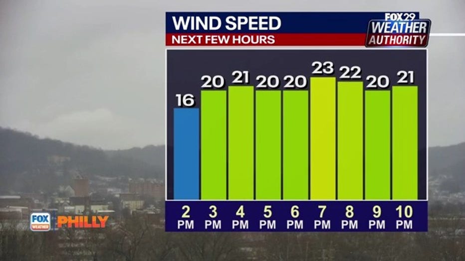
Along with the rain, forecasters expect strong wind gusts over 30 MPH around the city and even stronger in areas along the coast.
A flood advisory is in effect Saturday until 4:45 p.m. for portions of northern New Jersey and Pennsylvania, including the following counties: Hunterdon, Morris, Sussex and Warren Berks, Bucks, Carbon, Chester, Lehigh, Monroe, Montgomery and Northampton.
How long will it rain?
Forecasters expect the rain to move in around midnight with scattered downpours in Philadelphia and southern parts of New Jersey.
Rain will become steadier overnight as the system becomes more widespread, with heavy downpours expected around 7 a.m.
Rounds of downpours will stretch across the region as the day progresses through the afternoon and into the evening hours.
Rain is expected to be heaviest in the late afternoon before the storm starts to push offshore during the early evening.
How much rainfall is expected?
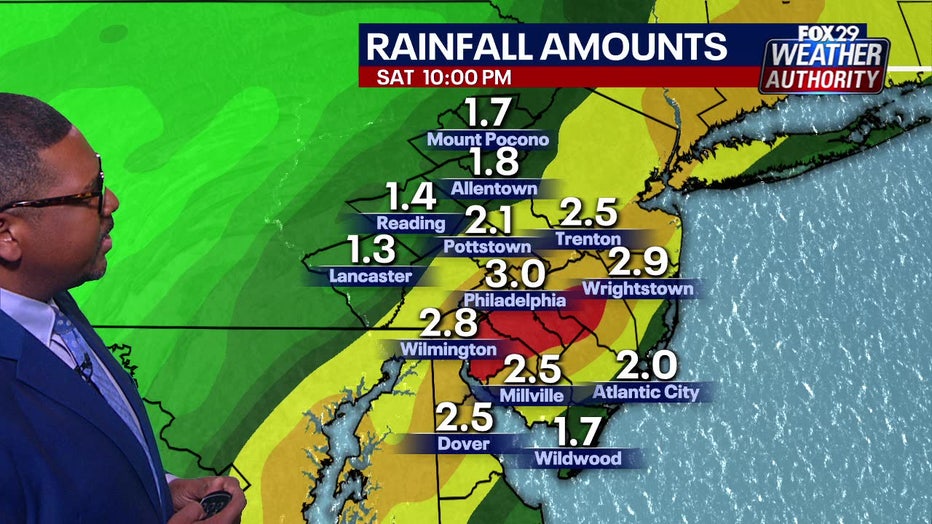
Philadelphia and parts of South Jersey could see up to 3 inches of rainfall.
Philadelphia and surrounding areas should expect upwards of 3 inches of rainfall from Saturday's soaker.
Parts of interior New Jersey will likewise see some of the highest rainfall totals, according to forecaster.
Areas north and west of the city will see rainfall totals around 2.5 inches, including Trenton and Pottstown.
Rainfall in Delaware and along the New Jersey coast will be around 2 inches.
Strong wind gusts
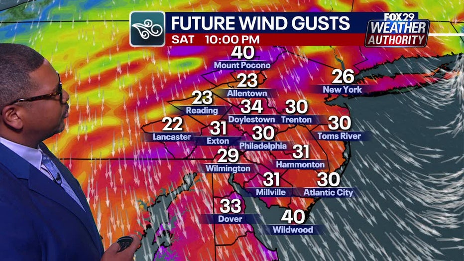
Along with the rain, forecasters expect strong wind gusts to blow upwards of 30 MPH at times.
Places along New Jersey's coast could see the strongest wind gusts of 40 MPH.
Places west of Philadelphia can expect weaker, but still mighty wind gusts around 20 MPH.
What's next?
Luckily, the rainstorm will be contained to Saturday, meaning outdoor activities will still be possible on Sunday.
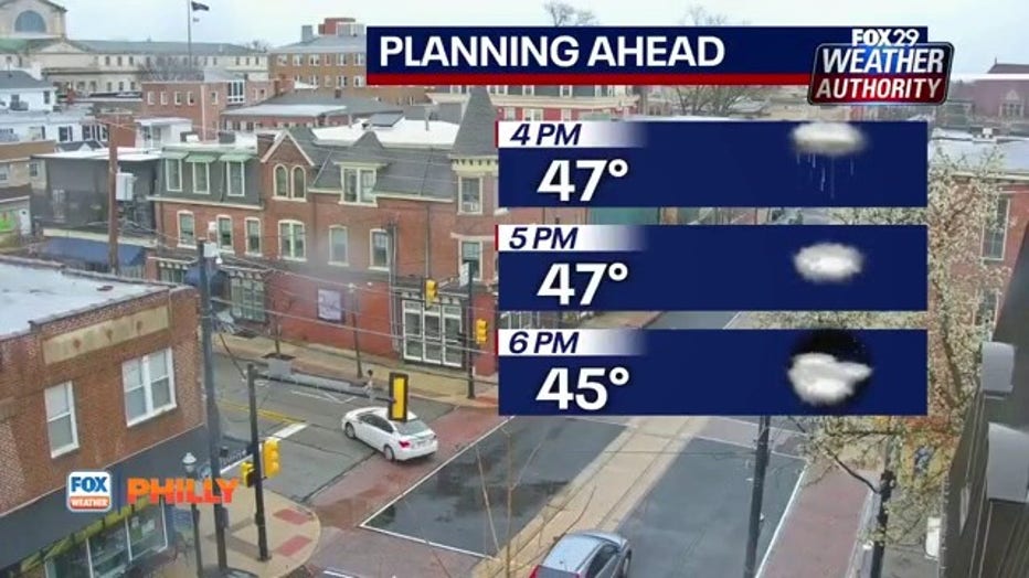
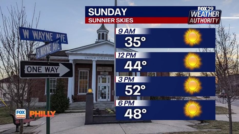
The sun will reemerge on Sunday with spotty clouds and blustery conditions that will make temps in the 50s feel much colder.
A similar weather day will follow on Monday before temperatures take a turn on Tuesday with highs approaching the 60s.
Another chance of rain is possible Wednesday through Friday, with balmy temperatures holding steady in the upper 50s.