

Sunday snowstorm could bring up to half a foot of snow to some areas

Weather Authority: Snow on Sunday could bring up to 6 inches
FOX 29's Scott Williams has the latest on Sunday's snowfall.
PHILADELPHIA - Most of the region will wake up to a wintry mix on Sunday as another system of snow pushes its way into our area. Snowfall totals could reach half a foot by the time the storm moves offshore late Sunday afternoon.
The National Weather Service upgraded its Winter Storm Watch to a Winter Storm Warning for parts of the region on Saturday. The warning spans areas along the I-95 corridor from northern Delaware through Philadelphia and Trenton.
Meanwhile, counties to the north of Philadelphia and coastal regions of southern New Jersey remain under a winter storm advisory.
The latest models show snow engulfing most of the region by 7 a.m. with light-to-moderate snow in Philadelphia and surrounding counties. The rain-snow line will shade just east of the I-95 corridor and push towards the shore as the morning progresses giving way to widespread snowfall.
By 1 p.m. heavy, wet snow will fall across the region as temperatures hold around the freezing point. The heaviest bands of snow are expected south and east of Philadelphia.
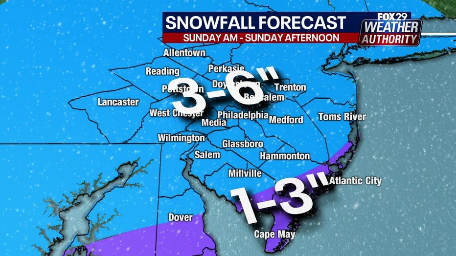
Snowfall will begin to taper off during the late afternoon as the storm pulls offshore. FOX 29's Weather Authority expects most areas to see 3 to 6 inches of snow by Sunday night.
For the latest updates on the upcoming winter storm, download the free FOX 29 Weather Authority app.
___
For the latest local news, sports and weather, download the FOX 29 News app.
DOWNLOAD: FOX 29 NEWS APP
Sign up for emails from FOX 29, including our daily Good Day Digest newsletter