

Philadelphia snow forecast: Several inches blanket region as snowfall ends, sun shines

How much snow has fallen in the Philadelphia area so far?
From a coating in South Jersey to more than a foot in the Poconos, FOX 29's Sue Serio breaks down how many inches of snow Philadelphia and its surrounding has seen as the storm comes to an end.
PHILADELPHIA - Another winter storm has come and gone in the Delaware Valley, dumping anywhere from more than a foot of snow to just a light coating across the region.
The snow officially arrived in the Philadelphia area in the early morning hours after dumping several inches on the Poconos and Lehigh Valley overnight.
South Jersey and Delaware have even seen some flakes as snow continues to accumulate across the region.
Timing out the storm

Snow starting to fall across Philadelphia area
The rain has officially changed over to wet snow as flakes start to come down across the city, creating slick roads.
FOX 29's Sue Serio says the snowfall started to wind down around noon in Philadelphia and its surrounding suburbs as the storm makes its way past the coast.
The changeover from rain to snow happened earlier than expected, meaning snow accumulation could reach the higher end of Monday's projections.
Roads in the city are now mostly covered with slush as temperatures continue to drop, creating slick streets and sidewalks. Meanwhile, counties in northern Pennsylvania have been completely coated in snow for most of the day.

Snow falls across Lehigh Valley as Philadelphia braces for morning snowfall
Snow has been falling in the mountains and across the Lehigh Valley for several hours, blanketing the roads. Now, the Philadelphia area is preparing for overnight rain to turn into snow and a wintry mix just in time for rush hour.
Remnants of the storm could remain for part of the region, but the sun is already starting to peak through as temperatures start to rise through the afternoon.
Snow totals
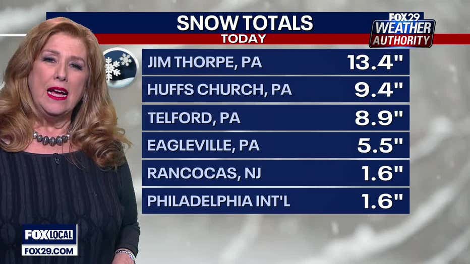
How much snow has fallen in the Delaware Valley so far?
In Pennsylvania, northern counties have already gotten more than a foot; Bucks, Chester and Montgomery counties are seeing totals between 7–8 inches; and about 2 inches fell in Philadelphia.
In New Jersey, Mercer County measured at just over 2 inches, while Camden and Burlington counties saw at least an inch of snow.
Just a coating in Delaware, where mostly soaking rain fell during the storm.
However, these totals could all still grow as the remainder of the storm moves offshore.
Delayed, canceled flights

Dozens of flights canceled, delayed at Philadelphia International Airport
Heather Redfern, a spokesperson for the airport, joined Good Day Philadelphia to share the latest information about dozens of flight delays and cancelations at the airport.
Dozens of arrivals and departures at Philadelphia International Airport were canceled or delayed Tuesday due to winter weather.
Airline tracking website FlightAware reports that there were over 100 flights delayed and at least 30 canceled.
Tricky travel
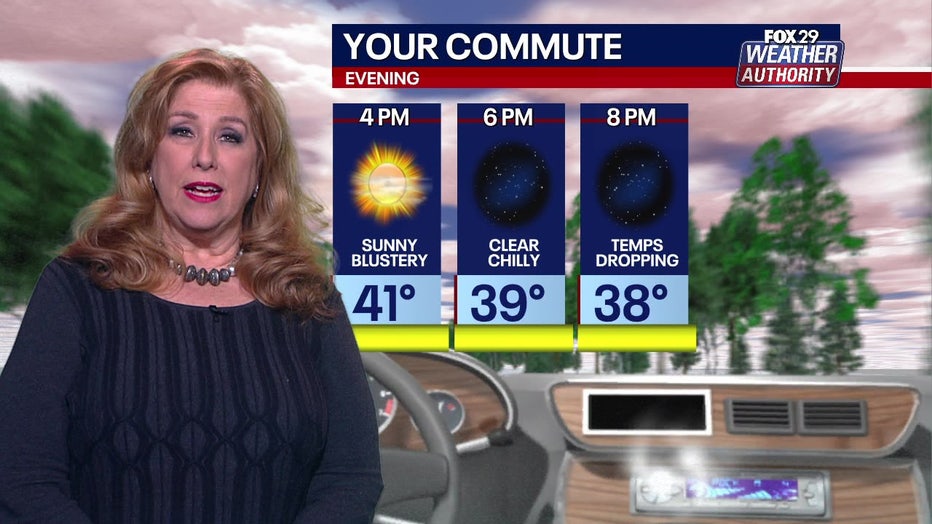
If you have to be out on the roads at all on Tuesday, allow some extra time to get where you need to go!
Wet snow has created slushy, slick roads, which could make driving conditions more difficult heading into the evening commute.
PennDOT has restored speed limits on several interstates and highways after reducing them to 45 mph Tuesday morning.
Warnings, watches and advisories
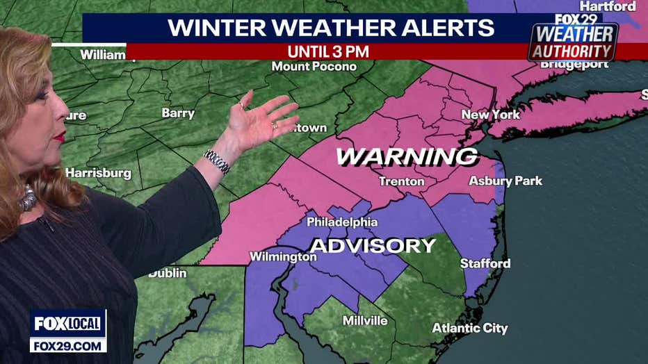
Although the snowstorm is winding down across the region, several winter storm alerts remain in effect until 3 p.m.
The National Weather Service has issued a Winter Storm Warning for the Lehigh Valley, the Poconos and Reading.
Mercer, Middlesex and Morris counties in New Jersey, and parts of Bucks and Montgomery counties are under a Winter Weather Advisory.
With flooding a major concern for the incoming storm, Coastal Flooding Warnings and Advisories have been issued for southern New Jersey and all of Delaware.
The Atlantic coastal NJ & DE, DE Bay, and tidal DE River can expect minor to moderate coastal flooding and high tides through Tuesday night.
Wind gusts
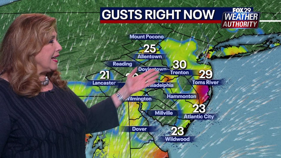
Along with snow and rain, forecasters are predicting some strong wind gusts that will be the most intense along New Jersey's coast.
Forecasters say winds will blow above 30 MPH in Philadelphia and surrounding areas, and even slightly stronger in parts of interior New Jersey.
Wind gusts will be far less powerful in areas to the far north and west of Philadelphia where the snowfall totals are expected to be higher.
Coastal New Jersey should brace for the storm's strongest wind gusts that could be above 40-50 mph which may result in isolated wind damage and power outages.